2906 Estate · Neighbourhoods Gozo · Neighbourhood edition

Northwestern Gozo

L-Għasri

A parish square, a lighthouse on the hill, a valley opening to the sea. Three distinct destinations shape a visit to this corner of Gozo. Start with the village, then choose your next stop.

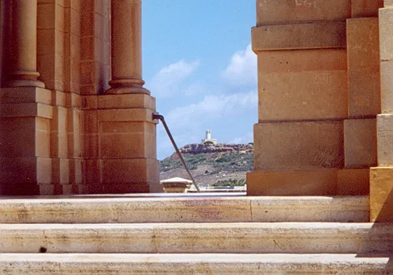
Ta’ Ġurdan lighthouse on a distant hill, seen through stone openings at Ta’ Pinu
Ta’ Ġurdan lighthouse viewed through Ta’ Pinu, 15 July 2008. Michael Newman / Wikimedia Commons · CC BY 3.0. WebP rendition via Merħba.

A base in the village

The Corpus Christi parish church anchors the village around Pjazza s-Salvatur. Visit Gozo records its construction in the early twentieth century and the establishment of the independent parish in 1921. The square is a useful starting point for orientation; the lighthouse and the coastal inlet are separate outings.

Everyday supplies

Lighthouse Supermarket’s Għasri outlet is listed on Triq il-Fanal. Josefa’s stockist directory independently identifies its Għasri shop on Lighthouse Street. Check the outlet’s current stock and service hours before planning your shopping.

Lighthouse Għasri · Stockist directory

Council and local life

The local council lists its office at 6 Triq Dun Karm Caruana. Its website provides a starting point for local services and notices. For the history behind the church and surrounding countryside, use the council’s geography and history guide.

Council office · Village history

Dining in the neighbours

For a separately planned meal, Il-Baldakkin is at the Kempinski resort in San Lawrenz. Use the operator’s menu and access information when making arrangements. The neighbouring Għarb guide offers another locality to explore for dining; these venues are outside Għasri.

Il-Baldakkin · San Lawrenz · Għarb guide

Choose the hill or the valley

Ta’ Ġurdan lighthouse rises above the village. The historic photograph shows it from Ta’ Pinu, with the shrine’s stonework in the foreground. Check the approach and current access arrangements before going; the photograph does not establish that the lighthouse interior is open.

The chapel of Our Lady of Patronage sits on the village edge toward the valley. Wied il-Għasri continues toward a narrow coastal inlet. The official Salt Pans walking leaflet describes the gorge and cliff-side steps to the pebble shore. Check the current approach, weather and sea conditions locally before a coastal visit.

Choose each destination deliberately. The orientation map below marks the parish church in the village; it supplies no walking route down to the inlet or up to the lighthouse. Travel between the village, hill and coast needs its own land-access check.
Arrive with a destination in mind

Route 308 is listed as Victoria–Għasri–Victoria. The operator identifies Fanal 1894, Nazzarenu 1895 and Għasri 1896 among its stops. Choose the stop that suits your plans and check the date-specific journey planner before departure. This village service does not establish transport directly to the gorge shore or the lighthouse entrance.

Victoria provides another useful guide for the wider day, while nearby Għarb and San Lawrenz have their own village centres and coastal destinations. Keep the locality names separate when arranging a meal, checking a bus stop or choosing accommodation.

Find the parish church

The marker shows the Corpus Christi church footprint in L-Għasri, not an entrance or a route to the coast.

Map data © OpenStreetMap contributors.

Sources and nearby editions

Editorial sources reviewed 17 November 2026.

Explore Għarb ↗ · Explore San Lawrenz ↗ · Explore Victoria ↗

Nexus Marketplace

Explore L-Għasri

See local homes and explore food, shops and everyday places around the neighbourhood.

Homes in L-Għasri

Browse local listings

Places around L-Għasri

Mapped places within 2 km of the centre. This can include nearby neighbourhoods.

Explore other neighbourhood editions