2906 Estate · Neighbourhoods Gozo · Neighbourhood edition

Southwestern Gozo

Ix-Xlendi

A bay at the foot of the cliffs. Come for the waterfront, plan a meal by the shore, or arrange a dive with a local operator. Xlendi has its own coastal character within the Munxar council area.

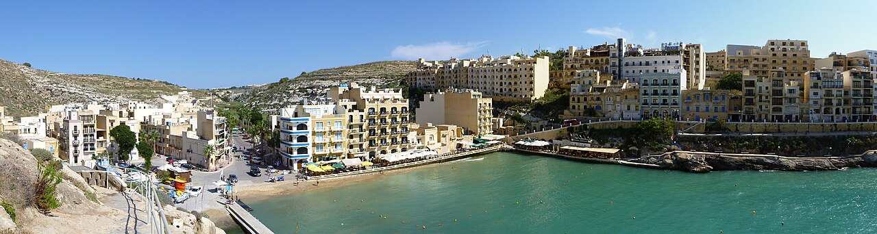
Panorama of the inner Xlendi bay, small beach and waterfront buildings
The inner Xlendi bay, 5 October 2012. Wusel007 / Wikimedia Commons · CC BY-SA 3.0. Resized JPEG rendition via Merħba.

Choose your kind of bay day

A small beach, waterfront buildings and the surrounding cliffs frame Xlendi. Visit Gozo describes its origins as a fishing village. The bay is a destination in its own right; the inland village of Munxar and the coastal tower each deserve a separate place in your plans.

A waterfront meal

Ta’ Karolina locates itself at the right end of the waterfront, near the steps toward Karolina Cave. Its menu includes pasta, seafood, meat dishes and pizza. Browse the current menu and ask the restaurant about a table for your date.

Ta’ Karolina · Current menu

Arrange a dive

Gozo Dive St Andrew’s is based at Xlendi Bay. Its website describes beginner, guided and technical diving options. Discuss your experience and the conditions with the operator before choosing an activity; the programme depends on the dive you can safely undertake.

Gozo Dive St Andrew’s

Bay and village

Xlendi falls within Munxar Local Council. The council’s office is inland on Profs. Ġuże’ Aquilina Street in Munxar. Use its notices and service pages for local matters, and keep the office’s location distinct from the waterfront.

Council services · Office information

Look beyond the waterfront

Visit Gozo’s Xlendi guide identifies the coastal watchtower, built in 1650, as a landmark separate from the beach. Choose the tower as its own destination and check the current approach before setting off.

The cliffs and coastal paths are part of Xlendi’s wider setting. The official Xlendi walking leaflet gives historical planning context. Current weather and access still need checking locally, particularly around the steps and exposed shoreline.

The map below marks a bus platform beside the bay. It draws no walking line across the water or toward the tower. Use a verified land route for a coastal outing, and check sea conditions before entering the water.
Plan the rest of the day

Route 306 and route 330 connect Victoria and Xlendi. Both operator pages identify Xlendi stop 1827. Route 306 also lists Munxar stop 4007. Select your direction and date in the journey planner before travelling.

A wider shopping or services trip can be planned with the separate Victoria guide and Fontana guide. Those inland destinations have their own context. Check the actual business and its current service arrangements before making a special journey.

For an Xlendi stay, compare the accommodation’s actual street and access with the activities you intend to do. A photograph of the bay does not establish a particular home’s view or an accessible route from its door. Use the precise address when checking transport and arrival arrangements.

Find the bay-side bus stop

The marker identifies Xlendi bus platform 1827, beside the bay. It is an orientation point, not a property pin or a coastal walking route.

Map data © OpenStreetMap contributors.

Sources and nearby editions

Editorial sources reviewed 18 November 2026. The historic photograph shows the bay in 2012. Check current menus, transport and coastal access with the relevant operator.

Explore Victoria ↗ · Explore Fontana ↗ · Explore Sannat ↗

Nexus Marketplace

Explore Ix-Xlendi

See local homes and explore food, shops and everyday places around the neighbourhood.

Homes in Ix-Xlendi

Browse local listings

Places around Ix-Xlendi

Mapped places within 2 km of the centre. This can include nearby neighbourhoods.

Explore other neighbourhood editions